From the writings of Mrs. Earl Hayner
As our 200th anniversary nears, it is nearly impossible to get a truly accurate picture of what Stillwater Village looked like in 1816.
Written descriptions are few and far between and there are few pictures being that it was before the days of cameras and daguerreotypes. No map can be found either, not even a sketch.
We know there were churches, houses, shops, and mills with their appropriate sites. But besides that, everyone must use their own imagination with scant material furnished and form their own picture of what the village must have looked like. No one has a true idea.
To begin with, the Waterford and Turnpike Roads built a few years before in 1807 followed the route of our present Hudson Avenue – straight over the top of the hill – Barrack Hill as it was called because the old Revolutionary War barracks stood on the south brow of the hill.
Apparently, its site was demolished when the turnpike was put through but suspect many of its heavy hand hewed timbers had been utilized in buildings on the hill before this. However, the name Barrack Hill was still in use.
he old Albany – Ft. Edward Road had swerved to the west to avoid the hill, then steeper and more rugged than a new – worn down by traffic and graded by machinery through the past now 200 years. It is a puzzle to follow the course of the old road today. It proceeded to the north by what is now Major Dickinson Avenue, continued what was the Presbyterian Episcopal Churches across the swamps and back to the present by Owen Campbell (now Bert Mang’s home.)
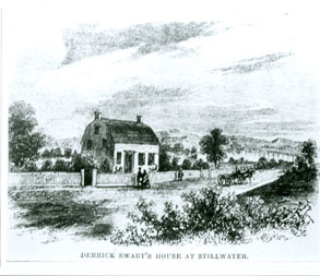
At the foot of the hill another road led around to the docks and storehouses on the riverbanks. These were behind the Dirck Swart House (Bill Knibb) and continued down to the beginning of the rifts behind Wilbur’s house – now the James Hickey residence.
The dam did not exist at that time. The road led quite close to the front of the Dirck Swart House then north past the entrance of Ferry Lane near the Campbell (Mang) house. A trace of evidence of this old road can still be seen leading north about half way down Ferry Lane.
Everybody knew that a village with water possessing water power verses portaging was headed for a bright future. American manufactures had been encouraged by the interference with our commerce and stopping of imports during the war (War of 1812) Now in 1816, a protective tariff had passed and successful American manufacture ring was assured. True, the transportation was obstructed by “unpleasant rapids” at Stillwater in the river but the canal would take care of that.
There must have been a lot of talk at the taverns and church sheds, blacksmith shops and the Post Office where the mail arrived and George Palmer handed out the weekly newspapers.
These stages stopped at not only specific taverns to rest their horses and refresh their passengers, but also often on long stretches of road where there were inns to allow passengers to stretch their legs (limbs) after being bumped along rough roads in cramped positions.
One day a little boy running along the road after such an occurrence found a small cameo pin in the road evidently dropped by a passenger. He picked it up and took it home. His father told the innkeeper at the nearest stage stop but no claimant for the pin ever appeared. So the boy gave it to his sister and Mrs. Hayner had that pin.